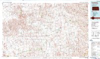
1985 Map of Protection
USGS Topo · Published 1988About this map
The Cimarron River winds through the southern reaches of this landscape, marking a transition between the plains of Kansas and Oklahoma. In the mid-1980s, the region was defined by a network of cattle-country settlements and vital transportation corridors. The Atchison Topeka and Santa Fe railroad serves as a spine for towns like Protection, Coldwater, and Ashland. The presence of the St Louis and Southwestern line near Bloom further illustrates the era's reliance on rail for moving agricultural goods.
Find a feature on this map
55 named features on this map. Tap any name to fly to it.
Don’t see what you’re looking for? This feature index may not catch every label — zoom into the map to look around manually.
Map Details
Editions of this 1985 Protection Map
2 editions found
Other maps of this area

1889 · Kinsley
USGS Topo · 1:125,000

1891 · Medicine Lodge
USGS Topo · 1:125,000

1892 · Kinsley
USGS Topo · 1:125,000

1892 · Meade
USGS Topo · 1:125,000

1892 · Dodge
USGS Topo · 1:125,000

1892 · Spearville
USGS Topo · 1:125,000

1892 · Coldwater
USGS Topo · 1:125,000

1892 · Pratt
USGS Topo · 1:125,000

1893 · Medicine Lodge
USGS Topo · 1:125,000

1894 · Spearville
USGS Topo · 1:125,000