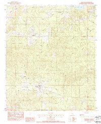
1983 Map of Provencal
USGS Topo · Published 1984About this map
Provencal serves as the primary hub of this Natchitoches Parish landscape, situated at the confluence of several local drainages and road networks. The town's layout and surrounding rural settlements like Hagewood and Victoria reflect a community integrated with the undulating terrain and the extensive waterways of the region. The map captures a detailed network of bayous and branches, including Mallard Bayou and Provencal Bayou, which define the natural boundaries and drainage of the area.
Find a feature on this map
45 named features on this map. Tap any name to fly to it.
Don’t see what you’re looking for? This feature index may not catch every label — zoom into the map to look around manually.
Map Details
Editions of this 1983 Provencal Map
2 editions found
Other maps of this area

1935 · Hagewood
USGS Topo · 1:31,680

1937 · Bermuda
USGS Topo · 1:31,680

1937 · Campti SE
USGS Topo · 1:31,680

1937 · Bellwood
USGS Topo · 1:31,680

1937 · Campti SW
USGS Topo · 1:31,680

1937 · Cypress
USGS Topo · 1:31,680

1938 · Allen
USGS Topo · 1:31,680

1942 · Many
USGS Topo · 1:62,500

1943 · Many
USGS Topo · 1:62,500

1943 · Provencal
USGS Topo · 1:62,500