
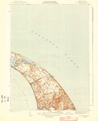
1887 Map of Provincetown
USGS Topo · Published 1887About this map
Province Lands and the densely clustered settlement of Provincetown define this late 19th-century coastal survey, revised in 1917. The map illustrates a landscape shaped by maritime necessity, with a remarkable density of navigational aids and safety infrastructure protecting the outer arm of Cape Cod. Along the Atlantic shore, a string of facilities including the Highland Life Saving Station and Race Point Life Saving Station stand watch over the dangerous sandbars, while prominent beacons like Cape Cod Light and Race Point Light guide vessels around the hook. Interior features reveal the natural geography of the dunes, from Shank Painter Pond and Duck Pond to the heights of Mt. Ararat and Town Hill. The survey also details the southeastern reaches into Truro, showing the scattered homesteads of North Truro and the winding course of the Pamet R.
Find a feature on this map
40 named features on this map. Tap any name to fly to it.
Don’t see what you’re looking for? This feature index may not catch every label — zoom into the map to look around manually.
Map Details
Editions of this 1887 Provincetown Map
This is the sole edition of this map. No revisions or reprints were ever made.
Other maps of this area

1887 · Wellfleet
USGS Topo · 1:62,500

1889 · Provincetown
USGS Topo · 1:62,500

1889 · Wellfleet
USGS Topo · 1:62,500

1893 · Wellfleet
USGS Topo · 1:62,500

1898 · Provincetown
USGS Topo · 1:62,500

1942 · Cape Cod Bay
USGS Topo · 1:125,000

1942 · Nauset
USGS Topo · 1:125,000

1944 · Provincetown
USGS Topo · 1:31,680

1944 · Wellfleet
USGS Topo · 1:31,680
1944 · North Truro
USGS Topo · 1:31,680