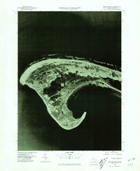
1977 Map of Provincetown
USGS Topo · Published 1981About this map
Provincetown sits at the very tip of Cape Cod, captured here in an orthophotograph based on 1977 aerial imagery. This specific format replaces traditional contour lines with rectified photography, revealing the stark contrast between the dense residential and maritime center of the town and the expansive, shifting sands of the surrounding dunes. The imagery shows the intricate shape of the harbor protected by the curved hook of the land, positioned between the deep waters of the Atlantic Ocean and the sheltered Cape Cod Bay. Local historians can observe the footprint of coastal development and natural sand migration exactly as they existed in the late seventies.
Find a feature on this map
4 named features on this map. Tap any name to fly to it.
Don’t see what you’re looking for? This feature index may not catch every label — zoom into the map to look around manually.
Map Details
Editions of this 1977 Provincetown Map
This is the sole edition of this map. No revisions or reprints were ever made.
Other maps of this area

1887 · Wellfleet
USGS Topo · 1:62,500

1887 · Provincetown
USGS Topo · 1:62,500

1889 · Provincetown
USGS Topo · 1:62,500

1889 · Wellfleet
USGS Topo · 1:62,500

1893 · Wellfleet
USGS Topo · 1:62,500

1898 · Provincetown
USGS Topo · 1:62,500

1942 · Cape Cod Bay
USGS Topo · 1:125,000

1944 · Provincetown
USGS Topo · 1:31,680
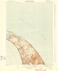
1944 · North Truro
USGS Topo · 1:31,680

1947 · Providence
USGS Topo · 1:250,000