
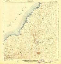
1928 Map of Puako
USGS Topo · Published 1928About this map
The volcanic coastline of West Hawaii is defined by the intersection of the South Kohala District and North Kona District on this 1928 topographic survey. The landscape is dominated by frozen history in the form of the massive Lava Flow of 1859, which reaches the sea near Anaehoomalu, and the Lava Flow of 1801 further south. These flows carve through ancient land divisions, revealing a network of coastal settlements and homesteads. Local life centers on the Puu Anahulu Homesteads and cattle ranching at the Huehue Ranch. Along the shore, numerous bays like Hapuna Bay and Puako Bay provide natural anchors for small coastal communities such as Puako and Kiholo. Higher elevations are marked by cinder cones and landmarks including Puu Waawaa and Puu Lili, connected by the Waimea Road and the Old Puuwaawaa Road.
Find a feature on this map
72 named features on this map. Tap any name to fly to it.
Don’t see what you’re looking for? This feature index may not catch every label — zoom into the map to look around manually.
Map Details
Editions of this 1928 Puako Map
2 editions found
Other maps of this area

1913 · Kohala
USGS Topo · 1:62,500

1916 · Kohala
USGS Topo · 1:62,500

1916 · Waipio
USGS Topo · 1:62,500

1927 · Kaohe
USGS Topo · 1:62,500

1928 · Kailua
USGS Topo · 1:62,500

1930 · Kaohe
USGS Topo · 1:62,500

1954 · Hawaii North
USGS Topo · 1:250,000

1956 · Puu Hinai
USGS Topo · 1:24,000

1956 · Kamuela
USGS Topo · 1:24,000

1956 · Keamuku
USGS Topo · 1:24,000