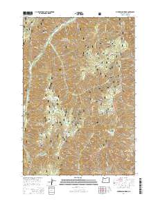
2014 Map of Puderbaugh Ridge
USGS Topo · Published 2014About this map
The Imnaha River flows through the northern reaches of this high-elevation terrain, passing the settlement of Fruita as it winds between the steep drainages of the Wallowa National Forest. This 2014 survey reveals a landscape dominated by dramatic vertical relief, where prominent landmarks like Puderbaugh Ridge and Summit Ridge divide a dense network of mountain creeks. Forest service access is documented through routes such as the Wallowa Mountain Loop and the River Canyon Rd, providing a framework for the remote timber and grazing lands of the region. The map also delineates the boundary with the Whitman National Forest, highlighting the vast public land management systems in place. Notable local landmarks including P O Saddle and McGraw Spring offer specific points of interest for those tracing the geographic history and land use patterns of Wallowa County.
Find a feature on this map
40 named features on this map. Tap any name to fly to it.
Don’t see what you’re looking for? This feature index may not catch every label — zoom into the map to look around manually.
Map Details
Editions of this 2014 Puderbaugh Ridge Map
This is the sole edition of this map. No revisions or reprints were ever made.
Other maps of this area

1920 · Seven Devils Mining District
USGS Topo · 1:48,000

1922 · He Devil
USGS Topo · 1:48,000

1954 · Harl Butte
USGS Topo · 1:62,500

1955 · Grangeville
USGS Topo · 1:250,000

1957 · He Devil
USGS Topo · 1:62,500

1957 · Cuprum
USGS Topo · 1:62,500

1957 · Homestead
USGS Topo · 1:62,500

1959 · Grangeville
USGS Topo · 1:250,000

1987 · Riggins
USGS Topo · 1:100,000
1990 · Puderbaugh Ridge
USGS Topo · 1:24,000