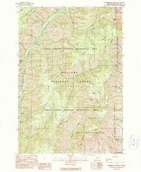
1990 Map of Puderbaugh Ridge
USGS Topo · Published 1990About this map
Imnaha River waters carve through this high-elevation corner of Wallowa County, defining a landscape of deep canyons and prominent divides. The map reveals the intricate drainage system of the Wallowa National Forest, where steep-banked tributaries like Crazyman Creek and Gumboot Creek feed into the primary river valley. Human activity in this remote backcountry is represented by recreational and utility landmarks, including the Mc Graw Lookout and the Borrow Pit near Rich Creek. High ridges such as Puderbaugh Ridge and Summit Ridge offer vantage points over the Hells Canyon National Recreation Area, while established sites like Blackhorse Campground and Ollokot Campground provide access points for those navigating the transition from forest to the protected Hells Canyon Wilderness boundary.
Find a feature on this map
33 named features on this map. Tap any name to fly to it.
Don’t see what you’re looking for? This feature index may not catch every label — zoom into the map to look around manually.
Map Details
Editions of this 1990 Puderbaugh Ridge Map
This is the sole edition of this map. No revisions or reprints were ever made.
Other maps of this area

1920 · Seven Devils Mining District
USGS Topo · 1:48,000

1922 · He Devil
USGS Topo · 1:48,000

1954 · Harl Butte
USGS Topo · 1:62,500

1955 · Grangeville
USGS Topo · 1:250,000

1957 · He Devil
USGS Topo · 1:62,500

1957 · Cuprum
USGS Topo · 1:62,500

1957 · Homestead
USGS Topo · 1:62,500

1959 · Grangeville
USGS Topo · 1:250,000

1987 · Riggins
USGS Topo · 1:100,000
1990 · Gumboot Butte
USGS Topo · 1:24,000