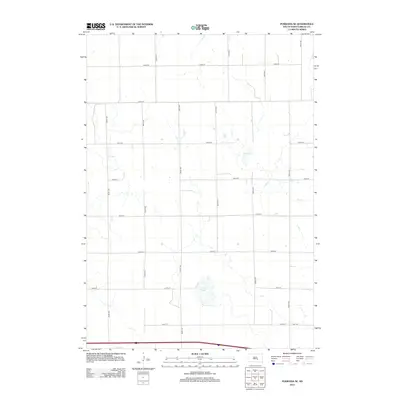
2012 Map of Pukwana SE
USGS Topo · Published 2012About this map
Silver Lake and Mud Lake provide the primary geographic relief in this high plains landscape of Brule County. This 2012 survey illustrates the rigid precision of the township and range system, where the terrain is dominated by a consistent grid of section lines including 243rd St and 250th St. These gravel and dirt roads, such as 354th Ave and 358th Ave, delineate the agricultural allotments typical of the South Dakota prairie. The map captures a quiet, rural sector of Smith Township where the land use is almost entirely dictated by these intersecting corridors, with few permanent structures or named landmarks beyond the natural depressions of the lake beds and the recurring rhythm of the county road network.
Find a feature on this map
16 named features on this map. Tap any name to fly to it.
Don’t see what you’re looking for? This feature index may not catch every label — zoom into the map to look around manually.
Map Details
Editions of this 2012 Pukwana SE Map
This is the sole edition of this map. No revisions or reprints were ever made.
Other maps of this area

1941 · Pukwana
USGS Topo · 1:62,500

1941 · Kimball North
USGS Topo · 1:62,500

1951 · Pukwana
USGS Topo · 1:62,500

1951 · Kimball North
USGS Topo · 1:62,500

1955 · Mitchell
USGS Topo · 1:250,000

1959 · Mitchell
USGS Topo · 1:250,000

1979 · Bijou Hills NE
USGS Topo · 1:24,000
1979 · Red Lake East
USGS Topo · 1:24,000

1979 · Kimball South
USGS Topo · 1:24,000
1982 · Kimball North
USGS Topo · 1:25,000