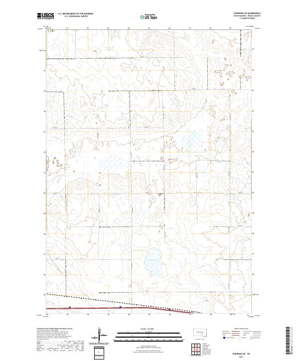
2021 Map of Pukwana SE
USGS Topo · Published 2021About this map
Silver Lake serves as the central focal point for this section of Brule County, anchoring a landscape defined by the rigid geometry of the Public Land Survey System. The area is organized around the intersection of several townships, including t104n r69w and t104n r68w, which dictate the placement of the rural road network. This grid is maintained by a series of north-south avenues such as 357th Ave and 359th Ave, intersected by east-west routes like 247th St and 250 St. The terrain is characterized by numerous small depressions and wetland pockets typical of the northern plains, with the larger body of Silver Lake providing a rare constant in the shifting prairie hydrology. While few named settlements appear, the map provides a precise layout of property boundaries and the infrastructure supporting this agricultural region in the early twenty-first century.
Find a feature on this map
18 named features on this map. Tap any name to fly to it.
Don’t see what you’re looking for? This feature index may not catch every label — zoom into the map to look around manually.
Map Details
Editions of this 2021 Pukwana SE Map
This is the sole edition of this map. No revisions or reprints were ever made.
Other maps of this area

1941 · Pukwana
USGS Topo · 1:62,500

1941 · Kimball North
USGS Topo · 1:62,500

1951 · Pukwana
USGS Topo · 1:62,500

1951 · Kimball North
USGS Topo · 1:62,500

1955 · Mitchell
USGS Topo · 1:250,000

1959 · Mitchell
USGS Topo · 1:250,000

1979 · Bijou Hills NE
USGS Topo · 1:24,000
1979 · Red Lake East
USGS Topo · 1:24,000

1979 · Kimball South
USGS Topo · 1:24,000
1982 · Kimball North
USGS Topo · 1:25,000