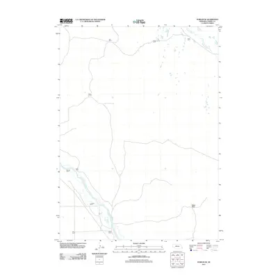
2011 Map of Purdum NE
USGS Topo · Published 2011About this map
The North Loup River winds through the southwestern corner of this Cherry County landscape, defining a corridor where historical landholdings like the Niemoth Ranch, Keller Ranch, and C C Wiese Ranch were established. The distribution of these named ranches across the quadrangle illustrates the sprawling pastoral economy of the Nebraska Sandhills in the early 21st century. To the northeast, Goose Creek meanders through a territory dotted with operations such as the Rogers Ranch and Vobdy Ranch. This 2011 survey captures a specific pattern of rural land use where family-named landmarks, including the Falter Place and Bestol Ranch, serve as the primary markers of human presence in a vast, water-carved environment.
Find a feature on this map
12 named features on this map. Tap any name to fly to it.
Don’t see what you’re looking for? This feature index may not catch every label — zoom into the map to look around manually.
Map Details
Editions of this 2011 Purdum NE Map
This is the sole edition of this map. No revisions or reprints were ever made.
Other maps of this area

1949 · Purdum
USGS Topo · 1:62,500

1949 · Koshopah
USGS Topo · 1:62,500

1949 · Long Lake
USGS Topo · 1:62,500

1951 · Long Lake
USGS Topo · 1:62,500

1951 · Purdum
USGS Topo · 1:62,500

1951 · Moon Lake
USGS Topo · 1:62,500

1951 · Koshopah
USGS Topo · 1:62,500

1957 · Valentine
USGS Topo · 1:250,000

1959 · Valentine
USGS Topo · 1:250,000
1985 · Long Lake SE
USGS Topo · 1:24,000