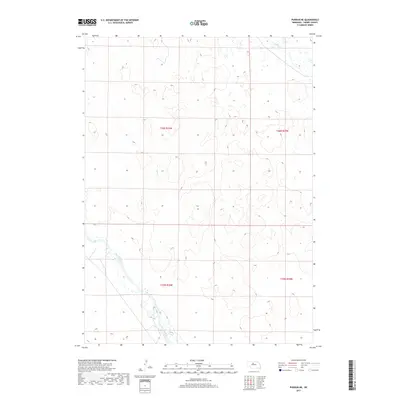
2017 Map of Purdum NE
USGS Topo · Published 2017About this map
The North Loup River winds through the southwestern corner of this Cherry County landscape, a defining feature of the Sandhills region in 2017. This area is characterized by its high concentration of wetlands and intricate drainage patterns, where small watercourses like Calf Cr and Goose Cr cut through the undulating terrain. The Public Land Survey System grid, established by the BLM, remains the primary organizational structure here, dividing the land into townships such as t26n r26w and t25n r25w. The map illustrates a largely unpopulated rural expanse where water sources dictate the placement of ranching infrastructure and local connectors, reflecting the sparse settlement patterns typical of this portion of Nebraska.
Find a feature on this map
7 named features on this map. Tap any name to fly to it.
Don’t see what you’re looking for? This feature index may not catch every label — zoom into the map to look around manually.
Map Details
Editions of this 2017 Purdum NE Map
This is the sole edition of this map. No revisions or reprints were ever made.
Other maps of this area

1949 · Purdum
USGS Topo · 1:62,500

1949 · Koshopah
USGS Topo · 1:62,500

1949 · Long Lake
USGS Topo · 1:62,500

1951 · Long Lake
USGS Topo · 1:62,500

1951 · Purdum
USGS Topo · 1:62,500

1951 · Moon Lake
USGS Topo · 1:62,500

1951 · Koshopah
USGS Topo · 1:62,500

1957 · Valentine
USGS Topo · 1:250,000

1959 · Valentine
USGS Topo · 1:250,000
1985 · Long Lake SE
USGS Topo · 1:24,000