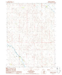
1986 Map of Purdum NE
USGS Topo · Published 1986About this map
The North Loup River meanders through the southern reaches of this landscape in the mid-1980s, defining a valley carved into the surrounding sandhills. This terrain is characterized by its sparse settlement and reliance on groundwater, evidenced by several wells and a notable Flowing Well located near Goose Creek in the northeast. The social and economic fabric of the area is anchored by established family operations, including Keys Ranch, Niemoth Ranch, and Rogers Ranch. The presence of these named sites, along with Bestol Ranch further south, highlights the enduring importance of ranching heritage in this part of Cherry County. Smaller watercourses like Calf Cr feed into the larger river system, supporting the livestock operations that dominate the region.
Find a feature on this map
11 named features on this map. Tap any name to fly to it.
Don’t see what you’re looking for? This feature index may not catch every label — zoom into the map to look around manually.
Map Details
Editions of this 1986 Purdum NE Map
This is the sole edition of this map. No revisions or reprints were ever made.
Other maps of this area

1949 · Purdum
USGS Topo · 1:62,500

1949 · Koshopah
USGS Topo · 1:62,500

1949 · Long Lake
USGS Topo · 1:62,500

1951 · Long Lake
USGS Topo · 1:62,500

1951 · Purdum
USGS Topo · 1:62,500

1951 · Moon Lake
USGS Topo · 1:62,500

1951 · Koshopah
USGS Topo · 1:62,500

1957 · Valentine
USGS Topo · 1:250,000

1959 · Valentine
USGS Topo · 1:250,000
1985 · Long Lake SE
USGS Topo · 1:24,000