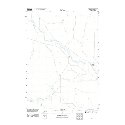
2011 Map of Purdum NW
USGS Topo · Published 2011About this map
The North Loup River winds through this section of the Nebraska Sandhills, defining the primary geography of a region dominated by large-scale ranching operations. The settlement of Cascade sits near the eastern edge of the map, while family-named holdings such as Pearson Ranch, Melville Ranch, and the Walking Circle Ranch are distributed across the drainage basins. The presence of numerous named ranches, including C E Wise Ranch and May Ranch, illustrates the enduring structure of land ownership and the cattle economy in this part of Cherry County. To the south, Calf Creek meanders past the Losh Ranch and Strunk Ranch, highlighting how water access dictates the placement of homesteads and infrastructure in this semi-arid landscape. This 2011 survey provides a clear view of the rural road network connecting these remote properties.
Find a feature on this map
12 named features on this map. Tap any name to fly to it.
Don’t see what you’re looking for? This feature index may not catch every label — zoom into the map to look around manually.
Map Details
Editions of this 2011 Purdum NW Map
This is the sole edition of this map. No revisions or reprints were ever made.
Other maps of this area

1948 · Seneca 4
USGS Topo · 1:62,500

1949 · Seneca 4
USGS Topo · 1:62,500

1949 · Purdum
USGS Topo · 1:62,500

1949 · Long Lake
USGS Topo · 1:62,500

1951 · Long Lake
USGS Topo · 1:62,500

1951 · Purdum
USGS Topo · 1:62,500

1951 · Brownlee
USGS Topo · 1:62,500

1957 · Valentine
USGS Topo · 1:250,000

1959 · Valentine
USGS Topo · 1:250,000
1985 · Long Lake SE
USGS Topo · 1:24,000