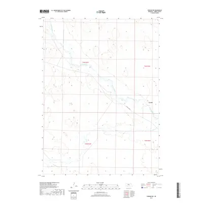
2017 Map of Purdum NW
USGS Topo · Published 2017About this map
The North Loup River meanders across this Cherry County landscape, defining the character of the Nebraska Sandhills as they appeared in 2017. The small settlement of Cascade sits along the river's path, serving as a localized point of human activity within an area otherwise dominated by large-scale ranching and land divisions. Flowing nearly parallel to the main river, Calf Cr threads through the southern portion of the quadrangle, illustrating the complex hydrography of the region's interdunal valleys. The primary thoroughfare, W North Loup Rd, follows the river valley, providing the essential link for the few structures and ranch properties scattered across the township lines of T26N and T25N. This survey documents the persistent rural patterns of northern Nebraska, where water sources and topographic contours dictate the placement of roads and homesteads.
Find a feature on this map
8 named features on this map. Tap any name to fly to it.
Don’t see what you’re looking for? This feature index may not catch every label — zoom into the map to look around manually.
Map Details
Editions of this 2017 Purdum NW Map
This is the sole edition of this map. No revisions or reprints were ever made.
Other maps of this area

1948 · Seneca 4
USGS Topo · 1:62,500

1949 · Seneca 4
USGS Topo · 1:62,500

1949 · Purdum
USGS Topo · 1:62,500

1949 · Long Lake
USGS Topo · 1:62,500

1951 · Long Lake
USGS Topo · 1:62,500

1951 · Purdum
USGS Topo · 1:62,500

1951 · Brownlee
USGS Topo · 1:62,500

1957 · Valentine
USGS Topo · 1:250,000

1959 · Valentine
USGS Topo · 1:250,000
1985 · Long Lake SE
USGS Topo · 1:24,000