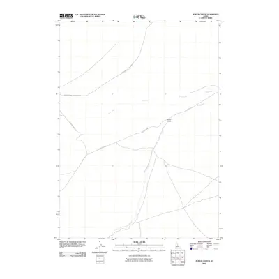
2010 Map of Purjue Canyon
USGS Topo · Published 2010About this map
Purjue Canyon and the surrounding high desert of Owyhee County are defined by a network of drainage systems and military aviation space in this 2010 survey. The landscape is dominated by the course of Shoofly Creek as it winds north toward the canyon, while Poison Creek cuts across the central plateau. A significant portion of the northern terrain is occupied by the Mountain Home Prec Bomb Range, highlighting the area's modern strategic use for training. Access through this sparsely populated region is maintained by a few established corridors, including Poison Creek Rd and Mud Flat Rd. The map illustrates a point in time where modern military footprints overlap with the ancient topography of the Idaho backcountry, offering a clear record of land use in a region primarily shaped by water and tactical necessity.
Find a feature on this map
8 named features on this map. Tap any name to fly to it.
Don’t see what you’re looking for? This feature index may not catch every label — zoom into the map to look around manually.
Map Details
Editions of this 2010 Purjue Canyon Map
This is the sole edition of this map. No revisions or reprints were ever made.
Other maps of this area

1947 · Grand View
USGS Topo · 1:62,500

1947 · Grand View
USGS Topo · 1:24,000

1947 · Chalk Hills
USGS Topo · 1:24,000

1947 · Vinson Wash
USGS Topo · 1:24,000

1947 · Perjue Canyon
USGS Topo · 1:24,000

1948 · Perjue Canyon
USGS Topo · 1:24,000

1948 · Vinson Wash
USGS Topo · 1:24,000
1948 · Grand View
USGS Topo · 1:24,000
1948 · Chalk Hills
USGS Topo · 1:24,000

1955 · Jordan Valley
USGS Topo · 1:250,000