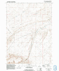
1992 Map of Purjue Canyon
USGS Topo · Published 1992About this map
Purjue Canyon Creek and Shoofly Creek carve through the high Idaho desert, defining the drainage patterns of this remote Owyhee County landscape. Revised from aerial photography in the late 1980s, the map reveals a terrain managed for livestock and water conservation, evidenced by the presence of a Corral, a Well, and a Guzzler. The network of seasonal waterways, including Twentymile Wash and Vinson Gulch, highlights the arid nature of the region where surface water is intermittent.
Find a feature on this map
15 named features on this map. Tap any name to fly to it.
Don’t see what you’re looking for? This feature index may not catch every label — zoom into the map to look around manually.
Map Details
Editions of this 1992 Purjue Canyon Map
This is the sole edition of this map. No revisions or reprints were ever made.
Other maps of this area

1947 · Grand View
USGS Topo · 1:62,500

1947 · Grand View
USGS Topo · 1:24,000

1947 · Chalk Hills
USGS Topo · 1:24,000

1947 · Vinson Wash
USGS Topo · 1:24,000

1947 · Perjue Canyon
USGS Topo · 1:24,000

1948 · Perjue Canyon
USGS Topo · 1:24,000

1948 · Vinson Wash
USGS Topo · 1:24,000
1948 · Grand View
USGS Topo · 1:24,000
1948 · Chalk Hills
USGS Topo · 1:24,000

1955 · Jordan Valley
USGS Topo · 1:250,000