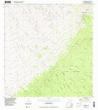
1995 Map of Puukinikini
USGS Topo · Published 2000About this map
Volcanic activity defines this portion of the Island of Hawaii, where the destructive history of Mauna Loa is recorded in distinct cooling paths. The map reveals the scarred landscape of the Lava Flow of 1926, the Lava Flow of 1919, and the Lava Flow of 1950, which cut across the high slopes of Kahuku. These frozen rivers of basalt contrast with the pockets of older vegetation, such as Kīpuka 'aiaka'ala'ā, which survived the surrounding eruptions.
Find a feature on this map
26 named features on this map. Tap any name to fly to it.
Don’t see what you’re looking for? This feature index may not catch every label — zoom into the map to look around manually.
Map Details
Editions of this 1995 Puukinikini Map
This is the sole edition of this map. No revisions or reprints were ever made.
Other maps of this area

1921 · Kilauea
USGS Topo · 1:62,500

1923 · Pahala
USGS Topo · 1:62,500

1924 · Kilauea
USGS Topo · 1:62,500

1924 · Honuapo
USGS Topo · 1:62,500

1928 · Mauna Loa
USGS Topo · 1:62,500

1954 · Hawaii South
USGS Topo · 1:250,000

1959 · Hawaii South
USGS Topo · 1:250,000

1961 · Hawaii South
USGS Topo · 1:250,000

1962 · Hawaii South
USGS Topo · 1:250,000
1966 · Mauna Loa
USGS Topo · 1:24,000