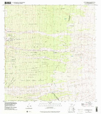
1995 Map of Puupohakuloa
USGS Topo · Published 2001About this map
Volcanic activity and traditional land divisions define this section of Hawaii's western slopes, where the Honokua Lava Flow of 1950 and the Alika Lava Flow of 1919 scarred the landscape within the South Kona Forest Reserve. The map documents the persistent Ahupua'a system through long, narrow land sections like Honokua, Pāhoehoe 1, and Opihihali 1 that stretch from the upland forests toward the sea. Pockets of human activity are visible at Hooper Camp and Ka'ohe Ranch, while agricultural history is noted in the Haukalua 2 Homesteads and Kukuiopa'e Homesteads. Rare water sources, essential for ranching and survival in this porous terrain, are meticulously marked at Lumiauai Waterhole and Polewai Waterhole. High-elevation landmarks like the cinder cone of Pu'upōhakuloa overlook the Kīpāhoehoe Natural Area Reserve, providing a clear record of the intersection between geologic force and human land management.
Find a feature on this map
48 named features on this map. Tap any name to fly to it.
Don’t see what you’re looking for? This feature index may not catch every label — zoom into the map to look around manually.
Map Details
Editions of this 1995 Puupohakuloa Map
This is the sole edition of this map. No revisions or reprints were ever made.
Other maps of this area

1924 · Honuapo
USGS Topo · 1:62,500

1928 · Mauna Loa
USGS Topo · 1:62,500

1928 · Hoopuloa
USGS Topo · 1:62,500

1954 · Hawaii South
USGS Topo · 1:250,000

1959 · Hawaii South
USGS Topo · 1:250,000

1959 · Honaunau
USGS Topo · 1:24,000
1960 · Kaunene
USGS Topo · 1:24,000

1961 · Hawaii South
USGS Topo · 1:250,000

1962 · Hawaii South
USGS Topo · 1:250,000

1962 · Milolii
USGS Topo · 1:24,000