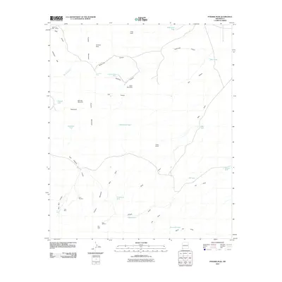
2010 Map of Pyramid Peak
USGS Topo · Published 2010About this map
The Pyramid Mountains dominate this arid landscape in southwestern New Mexico, defined by a series of rugged peaks and deep canyons. This high-desert terrain is marked by historical extraction and resource management, including the Silver Tree Mine, Venice Last Mine, and Allen Mine. Prospectors and ranchers navigated a network of drainages such as Muir Draw and Jose Placencia Canyon, where survival depended on the strategic placement of water infrastructure. Small livestock tanks like Graveyard Tank, Cement Dam Tank, and Nelson Tank punctuate the map, illustrating the vital role of water catchment in this environment. Notable landmarks include the prominent Pyramid Peak and the Red Windmill, which served as critical orientation points for those traversing the Leitendorf Hills.
Find a feature on this map
38 named features on this map. Tap any name to fly to it.
Don’t see what you’re looking for? This feature index may not catch every label — zoom into the map to look around manually.
Map Details
Editions of this 2010 Pyramid Peak Map
This is the sole edition of this map. No revisions or reprints were ever made.
Other maps of this area

1954 · Silver City
USGS Topo · 1:250,000

1958 · Silver City
USGS Topo · 1:250,000

1962 · Silver City
USGS Topo · 1:250,000

1962 · Lisbon
USGS Topo · 1:24,000

1963 · Lordsburg
USGS Topo · 1:24,000

1964 · Muir Ranch
USGS Topo · 1:24,000
1964 · South Pyramid Peak
USGS Topo · 1:24,000

1964 · Pyramid Peak
USGS Topo · 1:24,000
1964 · Table Top Mountain
USGS Topo · 1:24,000
1964 · Coyote Peak
USGS Topo · 1:24,000