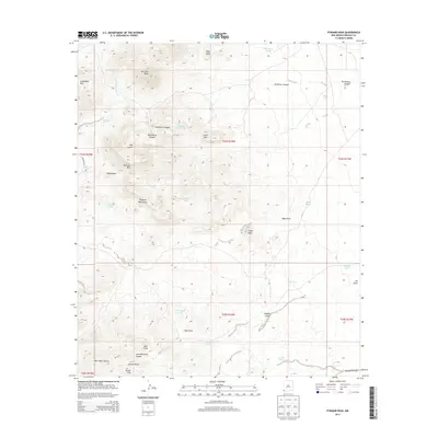
2013 Map of Pyramid Peak
USGS Topo · Published 2013About this map
Pyramid Mountains dominate this arid landscape in Hidalgo County, defined by a series of high peaks and deeply cut canyons. The terrain transitions from the Leitendorf Hills in the northwest toward the high elevation of Pyramid Peak, while drainage systems like Mansfield Wash and Bass Draw carve through the basin floor. Historically significant water sources, vital for ranching and travel in this high-desert environment, are documented through named features such as Mansfield Seep and Rockhouse Seep, along with numerous livestock tanks like Graveyard Tank and Dogs Head Tank. The presence of Jose Placencia Canyon and Russel Hills provides a link to early settlers and naming conventions of the region. Transportation is limited to rugged tracks and CO Road A010, reflecting the isolation of this corner of New Mexico during the early twenty-first century.
Find a feature on this map
40 named features on this map. Tap any name to fly to it.
Don’t see what you’re looking for? This feature index may not catch every label — zoom into the map to look around manually.
Map Details
Editions of this 2013 Pyramid Peak Map
This is the sole edition of this map. No revisions or reprints were ever made.
Other maps of this area

1954 · Silver City
USGS Topo · 1:250,000

1958 · Silver City
USGS Topo · 1:250,000

1962 · Silver City
USGS Topo · 1:250,000

1962 · Lisbon
USGS Topo · 1:24,000

1963 · Lordsburg
USGS Topo · 1:24,000

1964 · Muir Ranch
USGS Topo · 1:24,000
1964 · South Pyramid Peak
USGS Topo · 1:24,000

1964 · Pyramid Peak
USGS Topo · 1:24,000
1964 · Table Top Mountain
USGS Topo · 1:24,000
1964 · Coyote Peak
USGS Topo · 1:24,000