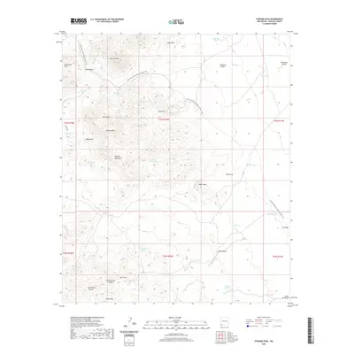
2020 Map of Pyramid Peak
USGS Topo · Published 2020About this map
Pyramid Peak and the high desert ridges of the Pyramid Mountains dominate this high-altitude landscape in Hidalgo County. The terrain is characterized by a network of drainage channels and catchments essential for life in this arid environment, including Mansfield Wash, Bass Draw, and the curiously named Graveyard Tank. Evidence of human movement and land use is sparse but significant, with the Continental Divide National Scenic Trail winding through the center of the sheet, crossing over Cedar Mtn and passing near Rimrock Mtn.
Find a feature on this map
43 named features on this map. Tap any name to fly to it.
Don’t see what you’re looking for? This feature index may not catch every label — zoom into the map to look around manually.
Map Details
Editions of this 2020 Pyramid Peak Map
This is the sole edition of this map. No revisions or reprints were ever made.
Other maps of this area

1954 · Silver City
USGS Topo · 1:250,000

1958 · Silver City
USGS Topo · 1:250,000

1962 · Silver City
USGS Topo · 1:250,000

1962 · Lisbon
USGS Topo · 1:24,000

1963 · Lordsburg
USGS Topo · 1:24,000

1964 · Muir Ranch
USGS Topo · 1:24,000
1964 · South Pyramid Peak
USGS Topo · 1:24,000

1964 · Pyramid Peak
USGS Topo · 1:24,000
1964 · Table Top Mountain
USGS Topo · 1:24,000
1964 · Coyote Peak
USGS Topo · 1:24,000