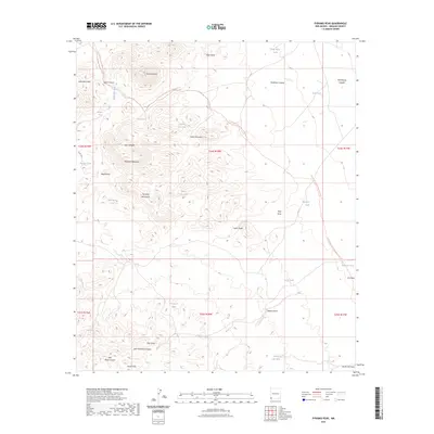
2023 Map of Pyramid Peak
USGS Topo · Published 2023About this map
Pyramid Peak stands as the central landmark in this high-desert landscape within the Pyramid Mountains. The region is defined by a sparse network of essential water sources, including Dogs Head Tank, Mansfield Seep, and the curiously named Graveyard Tank, reflecting the arid conditions and ranching history of Hidalgo County. The rugged topography is etched with deep drainages such as Gore Canyon and McWirter Canyon, while the Continental Divide National Scenic Trl winds through the eastern portion of the sheet. Named features like Jose Placencia Canyon and Muir Draw suggest early family land use and heritage in this isolated corner of New Mexico. The map illustrates a landscape of high ridges like Rimrock Mountain and the Leitendorf Hills, where seasonal washes such as Mansfield Wash provide the primary drainage system.
Find a feature on this map
43 named features on this map. Tap any name to fly to it.
Don’t see what you’re looking for? This feature index may not catch every label — zoom into the map to look around manually.
Map Details
Editions of this 2023 Pyramid Peak Map
This is the sole edition of this map. No revisions or reprints were ever made.
Other maps of this area

1954 · Silver City
USGS Topo · 1:250,000

1958 · Silver City
USGS Topo · 1:250,000

1962 · Silver City
USGS Topo · 1:250,000

1962 · Lisbon
USGS Topo · 1:24,000

1963 · Lordsburg
USGS Topo · 1:24,000

1964 · Muir Ranch
USGS Topo · 1:24,000
1964 · South Pyramid Peak
USGS Topo · 1:24,000

1964 · Pyramid Peak
USGS Topo · 1:24,000
1964 · Table Top Mountain
USGS Topo · 1:24,000
1964 · Coyote Peak
USGS Topo · 1:24,000