
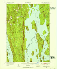
1952 Map of Quabbin Reservoir
USGS Topo · Published 1957About this map
The vast expanse of the Quabbin Reservoir dominates this central Massachusetts landscape, reflecting the massive mid-century transformation of the Swift River Valley. This revision, based on surveys from 1942 and 1952, captures the flooded valley where islands like Mount L and Russ Mtn rise from the water, marking what were once prominent highlands. Along the western shore, the Daniel Shays Highway traces the rugged terrain through New Salem, while the remnants of small communities such as Cooleyville and North Prescott remain visible on the upland fringes. The map illustrates a transitional era where the engineering of the Baffle Dam and the natural flow of Prescott Brook coexist. Topographical details such as Soapstone Hill and Prescott Hill provide critical context for local historians and genealogists looking to place family landmarks against the backdrop of this artificial inland sea.
Find a feature on this map
28 named features on this map. Tap any name to fly to it.
Don’t see what you’re looking for? This feature index may not catch every label — zoom into the map to look around manually.
Map Details
Editions of this 1952 Quabbin Reservoir Map
3 editions found
Other maps of this area

1887 · Warwick
USGS Topo · 1:62,500

1887 · Belchertown
USGS Topo · 1:62,500

1887 · Winchendon
USGS Topo · 1:62,500

1887 · Barre
USGS Topo · 1:62,500

1889 · Barre
USGS Topo · 1:62,500

1889 · Warwick
USGS Topo · 1:62,500

1890 · Belchertown
USGS Topo · 1:62,500

1890 · Winchendon
USGS Topo · 1:62,500

1893 · Belchertown
USGS Topo · 1:62,500

1894 · Winchendon
USGS Topo · 1:62,500