1992 Map of Quarryville
USGS Topo · Published 1994About this map
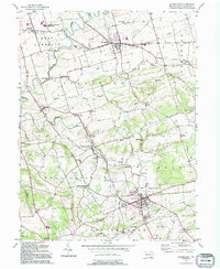
The Strasburg RR anchors this agricultural corridor of Lancaster County, cutting through the heart of the landscape between Strasburg and Quarryville. This 1992 photorevised map preserves the dense network of rural infrastructure that has long defined the region, from the Fish Hatchery near New Providence to the numerous one-room schoolhouses like Sandstone Sch and North Star Sch. The terrain is shaped by the winding course of Pequea Creek and the prominent rise of Mine Ridge, marking a distinct shift from the fertile valley bottoms to the more wooded upland heights of Eden and East Drumore townships. Social life is centered around institutions such as the Quarryville Presbyterian Home and the Lampeter-Strasburg High School, while specialized agricultural features like the Grain Elevator and various Grain Storage Bins illustrate the area's continued reliance on the local harvest economy.
Find a feature on this map
60 named features on this map. Tap any name to fly to it.
Don’t see what you’re looking for? This feature index may not catch every label — zoom into the map to look around manually.
Map Details
Editions of this 1992 Quarryville Map
This is the sole edition of this map. No revisions or reprints were ever made.
Other maps of this area

1902 · Lancaster
USGS Topo · 1:62,500

1904 · Lancaster
USGS Topo · 1:62,500

1906 · New Holland
USGS Topo · 1:62,500

1908 · New Holland
USGS Topo · 1:62,500

1912 · Quarryville
USGS Topo · 1:62,500

1912 · Mc Calls Ferry
USGS Topo · 1:62,500

1941 · New Holland
USGS Topo · 1:62,500

1943 · Lancaster
USGS Topo · 1:62,500

1943 · Quarryville
USGS Topo · 1:62,500

1943 · Mc Calls Ferry
USGS Topo · 1:62,500
Featured Places
- West Lampeter Township, PA
- Willow Street, West Lampeter Township
- Paradise Township, PA
- Quarryville, PA
- Strasburg, PA