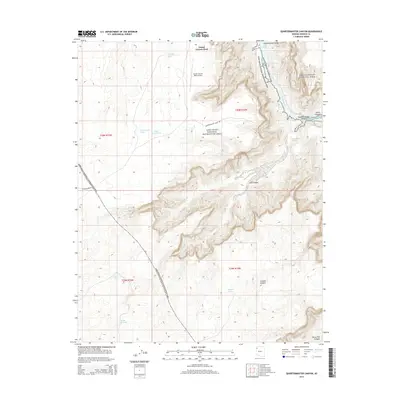
2014 Map of Quartermaster Canyon
USGS Topo · Published 2014About this map
Grand Canyon West Airport serves as a critical point of access on the high plateau overlooking the complex drainage systems of the Hualapai Reservation. The landscape is defined by deep incisions through the Colorado Plateau, where the Colorado River creates the Lower Granite Gorge and moves through turbulent stretches like Wards Cove Rapids and Waterfall Rapids. This 2014 survey documents a land managed through significant environmental designations, where Grand Canyon National Park meets the Lake Mead National Recreation Area. Human infrastructure is largely limited to seasonal water management and remote access, with features such as Boulder Tank, Jeff Tank, and Jackson Tank positioned across the high flats to support life in this arid region. Traces of historical movement and exploration remain visible in landmarks like Quartermaster Springs and the winding course of Quartermaster Point Rd.
Find a feature on this map
27 named features on this map. Tap any name to fly to it.
Don’t see what you’re looking for? This feature index may not catch every label — zoom into the map to look around manually.
Map Details
Editions of this 2014 Quartermaster Canyon Map
This is the sole edition of this map. No revisions or reprints were ever made.
Other maps of this area

1886 · Diamond Creek
USGS Topo · 1:250,000

1886 · Mt. Trumbull
USGS Topo · 1:250,000

1892 · Diamond Creek
USGS Topo · 1:250,000

1892 · Mt. Trumbull
USGS Topo · 1:250,000

1948 · Williams
USGS Topo · 1:250,000

1953 · Grand Canyon
USGS Topo · 1:250,000

1954 · Williams
USGS Topo · 1:250,000

1956 · Williams
USGS Topo · 1:250,000

1957 · Grand Canyon
USGS Topo · 1:250,000

1958 · Grand Canyon
USGS Topo · 1:250,000