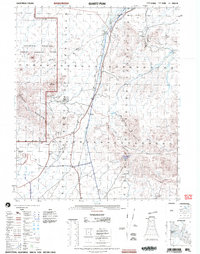
2002 Map of Quartz Peak
USGS Topo · Published 2004About this map
The Chocolate Mountain Aerial Gunnery Range dominates the western landscape of this Imperial County desert, demarcated by a prominent Military Reservation Boundary. This arid terrain is defined by its deep mining history, evidenced by numerous prospects and the established Paymaster Mine. Natural water sources, critical for survival and industry in this environment, are specifically identified at Midway Well, Arrowhead Spring, and the Peter Kane Water Hole.
Find a feature on this map
20 named features on this map. Tap any name to fly to it.
Don’t see what you’re looking for? This feature index may not catch every label — zoom into the map to look around manually.
Map Details
Editions of this 2002 Quartz Peak Map
This is the sole edition of this map. No revisions or reprints were ever made.
Other maps of this area

1903 · Yuma
USGS Topo · 1:125,000

1905 · Yuma
USGS Topo · 1:125,000

1907 · Holtville
USGS Topo · 1:125,000

1942 · El Centro
USGS Topo · 1:250,000

1942 · Yuma
USGS Topo · 1:250,000

1942 · Blythe
USGS Topo · 1:250,000

1945 · Picacho Peak
USGS Topo · 1:62,500

1945 · Cibola
USGS Topo · 1:62,500

1945 · Picacho
USGS Topo · 1:62,500

1951 · Picacho
USGS Topo · 1:62,500