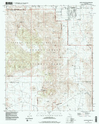
1995 Map of Queen Mountain
USGS Topo · Published 1998About this map
Twenty Nine Palms anchors the northern edge of this high-desert landscape, where residential streets like Alta Loma Drive and Base Line Street meet the rugged boundary of Joshua Tree National Park. The map reveals a complex history of extraction and early settlement, marking the locations of numerous historic workings including the Desert Queen Mine, Italy Mine, and Anaconda Mine. These sites, along with remnants like Pine City and Johns Camp, suggest a period of significant prospecting across the Queen Valley and surrounding foothills.
Find a feature on this map
47 named features on this map. Tap any name to fly to it.
Don’t see what you’re looking for? This feature index may not catch every label — zoom into the map to look around manually.
Map Details
Editions of this 1995 Queen Mountain Map
2 editions found
Other maps of this area

1942 · Amboy
USGS Topo · 1:250,000

1943 · Amboy
USGS Topo · 1:250,000

1943 · Pinkham Well
USGS Topo · 1:62,500

1944 · Pinkham Well
USGS Topo · 1:62,500

1944 · Pinyon Well
USGS Topo · 1:62,500

1947 · Santa Ana
USGS Topo · 1:250,000

1949 · Santa Ana
USGS Topo · 1:250,000

1953 · San Bernardino
USGS Topo · 1:250,000

1954 · Salton Sea
USGS Topo · 1:250,000

1954 · Needles
USGS Topo · 1:250,000