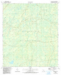
1990 Map of Queens Bay
USGS Topo · Published 1990About this map
Apalachicola National Forest dominates this landscape in Liberty County, revealing an intricate network of wetlands and drainage patterns as they appeared in the 1980s. The map illustrates a saturated terrain defined by named island groups within the swamp, such as the Black Cat Islands and Indian Creek Islands. These features, along with the expansive Queens Bay, suggest a region where seasonal water levels and dense vegetation dictate movement and land use. Small waterways like Spring Head Creek, Tiger Creek, and Saplin Head Creek provide fine-grained detail of the local hydrology. A designated Scenic Trail winds through the forest, offering a rare corridor of human passage through the largely undeveloped environment. The mapping of specific thickets and branches like Big Thick and Juniper Branch serves as a precise record of this coastal plain ecosystem before modern shifts in land management or climate could alter its delicate structure.
Find a feature on this map
17 named features on this map. Tap any name to fly to it.
Don’t see what you’re looking for? This feature index may not catch every label — zoom into the map to look around manually.
Map Details
Editions of this 1990 Queens Bay Map
This is the sole edition of this map. No revisions or reprints were ever made.
Other maps of this area

1943 · Lake Talquin
USGS Topo · 1:62,500

1944 · Queens Bay
USGS Topo · 1:24,000

1945 · Thousand Yard Bay
USGS Topo · 1:31,680

1945 · Smith Creek
USGS Topo · 1:31,680

1945 · Woods
USGS Topo · 1:31,680

1945 · Telogia
USGS Topo · 1:24,000

1946 · Queens Bay
USGS Topo · 1:31,680

1946 · Sumatra
USGS Topo · 1:31,680

1946 · Telogia
USGS Topo · 1:31,680

1946 · Owens Bridge
USGS Topo · 1:31,680