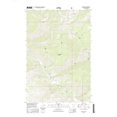
2017 Map of Quigg Peak
USGS Topo · Published 2017About this map
Quigg Peak dominates the northern reaches of this landscape within the Lolo National Forest, where a complex network of ridges and drainages defines the high country of Granite County. The western edge of the sheet is marked by the course of Rock Creek, a significant waterway that provides the primary access route via Rock Creek Rd. This drainage-fed terrain is characterized by a series of named gulches and ridges, such as Big Hogback Ridge and Little Hogback Ridge, which highlight the intricate natural topography of the Sapphire Mountains region.
Find a feature on this map
37 named features on this map. Tap any name to fly to it.
Don’t see what you’re looking for? This feature index may not catch every label — zoom into the map to look around manually.
Map Details
Editions of this 2017 Quigg Peak Map
This is the sole edition of this map. No revisions or reprints were ever made.
Other maps of this area

1903 · Bonner
USGS Topo · 1:125,000

1909 · Sapphire
USGS Topo · 1:125,000

1947 · Butte
USGS Topo · 1:250,000

1958 · Butte
USGS Topo · 1:250,000

1959 · Cleveland Mountain
USGS Topo · 1:62,500

1959 · Ravenna
USGS Topo · 1:62,500

1960 · Butte
USGS Topo · 1:250,000

1962 · Butte
USGS Topo · 1:250,000

1971 · Stony Creek
USGS Topo · 1:24,000
1974 · Stony Creek
USGS Topo · 1:24,000