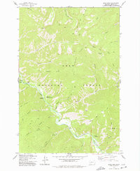
1975 Map of Quigg Peak
USGS Topo · Published 1978About this map
Rock Creek carves a deep valley through the heart of the Lolo National Forest in this mid-1970s mountain survey. The landscape is defined by the high elevation of Quigg Peak and the prominent spine of Big Hogback Ridge. This area served as a critical corridor for forest management and back-country access, as evidenced by the presence of the Rock Creek Forest Service Station and numerous campgrounds along the riverbank, including Hutsinpilar Campground and Camp Siria Campground. The presence of a Prospect near Weasel Gulch and several cable crossings indicates a working forest where mining and maintenance were ongoing tasks. An extensive network of pack trails, such as the Butte Cabin Trail and the Wyman Pack Trail, provided the primary means of navigating the steep gulches and ridges that feed into the main canyon.
Find a feature on this map
44 named features on this map. Tap any name to fly to it.
Don’t see what you’re looking for? This feature index may not catch every label — zoom into the map to look around manually.
Map Details
Editions of this 1975 Quigg Peak Map
This is the sole edition of this map. No revisions or reprints were ever made.
Other maps of this area

1903 · Bonner
USGS Topo · 1:125,000

1909 · Sapphire
USGS Topo · 1:125,000

1947 · Butte
USGS Topo · 1:250,000

1958 · Butte
USGS Topo · 1:250,000

1959 · Cleveland Mountain
USGS Topo · 1:62,500

1959 · Ravenna
USGS Topo · 1:62,500

1960 · Butte
USGS Topo · 1:250,000

1962 · Butte
USGS Topo · 1:250,000

1971 · Stony Creek
USGS Topo · 1:24,000
1974 · Stony Creek
USGS Topo · 1:24,000