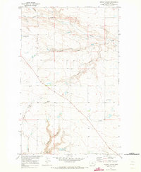
1970 Map of Quigley Coulee
USGS Topo · Published 1973About this map
Quigley Coulee and its neighboring seasonal drainages define this portion of Hill County, mapped during the expansion of the Missouri River Basin project. The landscape is marked by the erosion patterns of the northern plains, where Redrock Coulee and Lohman Coulee wind toward larger water systems. Human presence is concentrated along historic transit routes like the Amos Trail and Flagstaff Road. For local historians and genealogists, the Grainbelt Cem and the prominent Flagstaff Hill provide key orientation points within the township grid. Infrastructure of the era is represented by a remote Landing Strip, various Storage Bins, and evidence of resource extraction at the Gravel Pits and a northern Drill Hole. At the southern edge of the sheet, The Forks marks the meeting of Cherry Coulee and Supenau Coulee.
Find a feature on this map
18 named features on this map. Tap any name to fly to it.
Don’t see what you’re looking for? This feature index may not catch every label — zoom into the map to look around manually.
Map Details
Editions of this 1970 Quigley Coulee Map
This is the sole edition of this map. No revisions or reprints were ever made.
Other maps of this area

1904 · Havre
USGS Topo · 1:62,500

1904 · Assinniboine
USGS Topo · 1:62,500

1912 · Thibedeau Lake
USGS Topo · 1:125,000

1953 · Havre
USGS Topo · 1:250,000

1957 · Havre
USGS Topo · 1:250,000

1958 · Havre
USGS Topo · 1:250,000

1964 · Havre NW
USGS Topo · 1:24,000

1964 · Havre
USGS Topo · 1:24,000
1970 · Herron Park
USGS Topo · 1:24,000
1970 · Kiehns Coulee
USGS Topo · 1:24,000