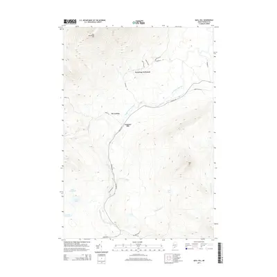
2014 Map of Quill Hill
USGS Topo · Published 2014About this map
The South Branch Dead River winds through this Franklin County landscape, shaping the development and transportation patterns of the early 21st century. The map illustrates a region defined by its timber and water resources, evidenced by the presence of Langtown Mill and the specific riverside site known as The Landing. Higher elevations such as East Kennebago Mtn and Quill Hill overlook a network of logging and access roads, including the historical echo of the Narrow Gauge Rd. Small, concentrated pockets of activity like Kennebago Settlement are connected by routes such as Stratton Rd and Rangeley Rd, which follow the natural contours of the river valleys. A series of water bodies including Greely Pond, Little Greely Pond, and Dill Pond further characterize this drainage basin, providing essential geographic context for land-use studies in this part of Maine.
Find a feature on this map
26 named features on this map. Tap any name to fly to it.
Don’t see what you’re looking for? This feature index may not catch every label — zoom into the map to look around manually.
Map Details
Editions of this 2014 Quill Hill Map
This is the sole edition of this map. No revisions or reprints were ever made.
Other maps of this area

1928 · Stratton
USGS Topo · 1:48,000

1929 · Phillips
USGS Topo · 1:48,000

1932 · Phillips
USGS Topo · 1:62,500

1932 · Stratton
USGS Topo · 1:62,500

1932 · Kennebago Lake
USGS Topo · 1:48,000

1933 · Rangeley
USGS Topo · 1:48,000

1935 · Kennebago Lake
USGS Topo · 1:62,500

1936 · Kennebago Lake
USGS Topo · 1:62,500

1939 · Rangeley
USGS Topo · 1:62,500

1949 · Jackman
USGS Topo · 1:250,000
Featured Places
- Dallas Plantation, ME
- Coplin Plantation, ME
- Kennebago Settlement, Lang Township
- Tim Pond Township, ME
- Lang Township, ME