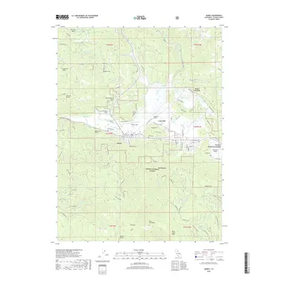
2018 Map of Quincy
USGS Topo · Published 2018About this map
The mountain town of Quincy serves as the focal point for this Plumas County survey, situated where Spanish Creek meets the broader valley floor. The map documents the residential and commercial layout of the community alongside East Quincy, capturing local landmarks like the Plumas County Fairgrounds and the campus of Feather River College. Industrial and transit history are visible through the siting of Cedar Mill and the convergence of roads at Quincy Junction to the north.
Find a feature on this map
99 named features on this map. Tap any name to fly to it.
Don’t see what you’re looking for? This feature index may not catch every label — zoom into the map to look around manually.
Map Details
Editions of this 2018 Quincy Map
This is the sole edition of this map. No revisions or reprints were ever made.
Other maps of this area

1886 · Honey Lake
USGS Topo · 1:250,000

1886 · Lassen Peak
USGS Topo · 1:250,000

1888 · Bidwell Bar
USGS Topo · 1:125,000

1891 · Bidwell Bar
USGS Topo · 1:125,000

1891 · Downieville
USGS Topo · 1:125,000

1891 · Honey Lake
USGS Topo · 1:250,000

1892 · Lassen Peak
USGS Topo · 1:250,000

1893 · Bidwell Bar
USGS Topo · 1:125,000

1893 · Honey Lake
USGS Topo · 1:250,000

1893 · Downieville
USGS Topo · 1:125,000