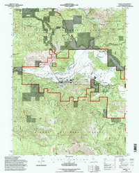
1994 Map of Quincy
USGS Topo · Published 1998About this map
American Valley serves as the focal point for this mid-1990s survey, where the seat of Plumas County and its surrounding mountain communities are documented in detail. The town of Quincy is the central hub, characterized by a mix of civic infrastructure like the County Hospital and USFS Supervisors Office alongside historic industrial markers. Evidence of the region’s long-standing mining and timber heritage is visible in the hills, from the Imperial Mine and Hungarian Placer Mine to the Cedar Mill located near Mill Creek.
Find a feature on this map
46 named features on this map. Tap any name to fly to it.
Don’t see what you’re looking for? This feature index may not catch every label — zoom into the map to look around manually.
Map Details
Editions of this 1994 Quincy Map
This is the sole edition of this map. No revisions or reprints were ever made.
Other maps of this area

1886 · Honey Lake
USGS Topo · 1:250,000

1886 · Lassen Peak
USGS Topo · 1:250,000

1888 · Bidwell Bar
USGS Topo · 1:125,000

1891 · Bidwell Bar
USGS Topo · 1:125,000

1891 · Downieville
USGS Topo · 1:125,000

1891 · Honey Lake
USGS Topo · 1:250,000

1892 · Lassen Peak
USGS Topo · 1:250,000

1893 · Bidwell Bar
USGS Topo · 1:125,000

1893 · Honey Lake
USGS Topo · 1:250,000

1893 · Downieville
USGS Topo · 1:125,000