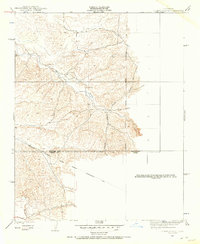
1926 Map of Quincy School
USGS Topo · Published 1957About this map
Quincy Sch stands as a central landmark in this 1920s topography, situated near the winding course of the White River. The landscape is defined by the transition from the rolling drainage of Tyler Gulch and Rag Gulch to the more level terrain of Telegraph Flat. Topography by Bishop Moorhead shows the area before modern development, capturing a rural interior where the Tulare Co Kern Co boundary line bisects the hills. The infrastructure of the era is represented by the massive Southern California Edison Company Transmission Line, which cuts across the southern portion of the map. To the southwest, Deepwell Ranch marks one of the few named settlements in this sparsely populated stretch of the valley foothills, reflecting the early cattle and ranching history of the region.
Find a feature on this map
9 named features on this map. Tap any name to fly to it.
Don’t see what you’re looking for? This feature index may not catch every label — zoom into the map to look around manually.
Map Details
Editions of this 1926 Quincy School Map
2 editions found
Other maps of this area

1926 · Quincy School
USGS Topo · 1:31,680

1929 · Richgrove
USGS Topo · 1:31,680

1929 · Quincy School
USGS Topo · 1:31,680

1929 · Ducor
USGS Topo · 1:31,680

1931 · Deepwell Ranch
USGS Topo · 1:31,680

1932 · Woody
USGS Topo · 1:62,500

1935 · Woody
USGS Topo · 1:62,500

1936 · White River
USGS Topo · 1:62,500

1936 · Tobias Peak
USGS Topo · 1:125,000
1942 · Slater
USGS Topo · 1:62,500