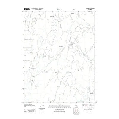
2012 Map of Rackerby
USGS Topo · Published 2012About this map
Rackerby and Brownsville anchor this 2012 study of the Yuba County foothills, an area defined by its deep ravines and historic ranching properties. The map documents a landscape where agricultural heritage meets modern aviation at the Brownsville Aero Pines Airport. For those tracing local family history, the Upham Cem remains a significant landmark near the center of the sheet, while family-named locales like Rose Ranch, Willow Glen Ranch, and Finley Ranch show the persistent footprint of large landholdings in northern California. Drainage patterns are intricate, with S Honcut Cr and its tributaries like Willow Glen Cr carving through the terrain toward Lake Mildred. The southern portion of the quadrangle highlights the settlement at Frenchtown, situated along Dry Cr, providing a clear view of the area's geography and established road networks.
Find a feature on this map
102 named features on this map. Tap any name to fly to it.
Don’t see what you’re looking for? This feature index may not catch every label — zoom into the map to look around manually.
Map Details
Editions of this 2012 Rackerby Map
This is the sole edition of this map. No revisions or reprints were ever made.
Other maps of this area

1888 · Smartsville
USGS Topo · 1:125,000

1888 · Bidwell Bar
USGS Topo · 1:125,000

1891 · Bidwell Bar
USGS Topo · 1:125,000

1891 · Smartsville
USGS Topo · 1:125,000

1892 · Smartsville
USGS Topo · 1:125,000

1893 · Bidwell Bar
USGS Topo · 1:125,000

1894 · Smartsville
USGS Topo · 1:125,000

1895 · Bidwell Bar
USGS Topo · 1:125,000

1895 · Smartsville
USGS Topo · 1:125,000

1897 · Bidwell Bar
USGS Topo · 1:125,000