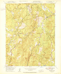
1950 Map of Rackerby
USGS Topo · Published 1950About this map
Gold-bearing hills and timber lands dominate this Sierra Nevada foothills landscape at the mid-century. The Butte Co Yuba Co line divides the terrain, where mining history is evident in the presence of the Central Pacific Mine, Manzanita Mine, and Three-in-One Mine. Small settlements like Rackerby, Brownsville, and Frenchtown serve as hubs for a region defined by ranching and resource extraction, with names such as Robinson Mills reflecting the area's industrial roots.
Find a feature on this map
50 named features on this map. Tap any name to fly to it.
Don’t see what you’re looking for? This feature index may not catch every label — zoom into the map to look around manually.
Map Details
Editions of this 1950 Rackerby Map
This is the sole edition of this map. No revisions or reprints were ever made.
Other maps of this area

1888 · Smartsville
USGS Topo · 1:125,000

1888 · Bidwell Bar
USGS Topo · 1:125,000

1891 · Bidwell Bar
USGS Topo · 1:125,000

1891 · Smartsville
USGS Topo · 1:125,000

1892 · Smartsville
USGS Topo · 1:125,000

1893 · Bidwell Bar
USGS Topo · 1:125,000

1894 · Smartsville
USGS Topo · 1:125,000

1895 · Bidwell Bar
USGS Topo · 1:125,000

1895 · Smartsville
USGS Topo · 1:125,000

1897 · Bidwell Bar
USGS Topo · 1:125,000