1986 Map of Radersburg
USGS Topo · Published 1986About this map
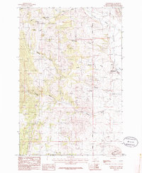
Radersburg serves as the focal point of this mid-1980s topographical study, situated at the eastern edge of the mountainous terrain that characterizes the region. The landscape is defined by deep drainage systems including Keating Gulch, Uncle Johnnys Gulch, and Charity Gulch, which all flow toward the flatter basins to the east. Extensive mining activity is evident across the slopes, marked by numerous Mine Shaft and Mine Shafts symbols, particularly concentrated in the vicinity of the town and along the gulches, pointing to the area's enduring industrial heritage.
Find a feature on this map
20 named features on this map. Tap any name to fly to it.
Don’t see what you’re looking for? This feature index may not catch every label — zoom into the map to look around manually.
Map Details
Editions of this 1986 Radersburg Map
This is the sole edition of this map. No revisions or reprints were ever made.
Other maps of this area

1886 · Fort Logan
USGS Topo · 1:250,000

1948 · White Sulphur Springs
USGS Topo · 1:250,000

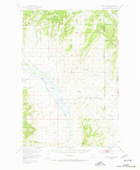
1949 · Radersburg
USGS Topo · 1:62,500
1950 · Devils Fence
USGS Topo · 1:62,500

1950 · Townsend
USGS Topo · 1:62,500
1950 · Clancy
USGS Topo · 1:62,500

1958 · White Sulphur Springs
USGS Topo · 1:250,000

1961 · White Sulphur Springs
USGS Topo · 1:250,000

1965 · White Sulphur Springs
USGS Topo · 1:250,000
1976 · Townsend
USGS Topo · 1:100,000