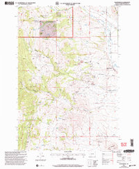
2001 Map of Radersburg
USGS Topo · Published 2004About this map
Radersburg stands at the eastern edge of a landscape defined by an intensive mining history, where the rugged terrain transitions from the Limestone Hills into the timbered slopes of the Helena National Forest. This 2001 revision of the area reveals an incredible density of mineral extraction sites concentrated along the various gulches. The industrial footprint is particularly dense within Keating Gulch and Johnnys Gulch, where numerous Mine Shafts, Adits, and Open Pit Mines are recorded alongside established operations like the Ohio Mines and Black Friday Mines. To the west, the landscape is deeply etched by watercourses such as Slim Sam Creek and the South Fork, while scattered springs like Piedmont Spring provided vital water sources for early mining and ranching interests. This map serves as a detailed record of the mining claims and topographical developments that shaped Broadwater County long after the initial gold rush era.
Find a feature on this map
41 named features on this map. Tap any name to fly to it.
Don’t see what you’re looking for? This feature index may not catch every label — zoom into the map to look around manually.
Map Details
Editions of this 2001 Radersburg Map
This is the sole edition of this map. No revisions or reprints were ever made.
Other maps of this area

1886 · Fort Logan
USGS Topo · 1:250,000

1948 · White Sulphur Springs
USGS Topo · 1:250,000

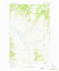
1949 · Radersburg
USGS Topo · 1:62,500
1950 · Devils Fence
USGS Topo · 1:62,500

1950 · Townsend
USGS Topo · 1:62,500
1950 · Clancy
USGS Topo · 1:62,500

1958 · White Sulphur Springs
USGS Topo · 1:250,000

1961 · White Sulphur Springs
USGS Topo · 1:250,000

1965 · White Sulphur Springs
USGS Topo · 1:250,000
1976 · Townsend
USGS Topo · 1:100,000