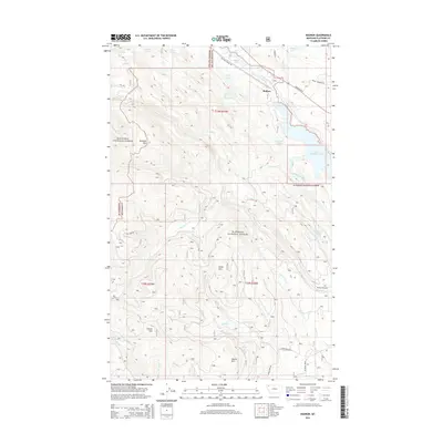
2014 Map of Radnor
USGS Topo · Published 2014About this map
Radnor sits at the northern edge of this Montana landscape where the Stillwater River flows through a narrow corridor alongside Highway 93 N. This 2014 survey documents a rugged mountain transition zone where the Kootenai National Forest and Flathead National Forest meet. The geography is defined by significant vertical relief, climbing from the river valley to summits like Ketowke Mtn and Adams Mtn. The map reveals a high concentration of alpine water bodies, including Lagoni Lake, Upper Stillwater Lake, and the descriptively named Hole in the Wall Lake. Transportation routes here range from modern pavement to the historical path of the Old Fort Steele Trl, which parallels the river. A network of service roads, such as Martin Creek Rd, provides access into the interior drainages of Miller Cr and Potter Cr, which feed the Stillwater system.
Find a feature on this map
41 named features on this map. Tap any name to fly to it.
Don’t see what you’re looking for? This feature index may not catch every label — zoom into the map to look around manually.
Map Details
Editions of this 2014 Radnor Map
This is the sole edition of this map. No revisions or reprints were ever made.
Other maps of this area

1913 · Stryker
USGS Topo · 1:125,000

1916 · Stryker
USGS Topo · 1:125,000

1957 · Kalispell
USGS Topo · 1:250,000

1960 · Kalispell
USGS Topo · 1:250,000

1961 · Kalispell
USGS Topo · 1:250,000

1962 · Johnson Peak
USGS Topo · 1:24,000
1962 · Tally Lake
USGS Topo · 1:24,000

1963 · Stryker
USGS Topo · 1:24,000

1963 · Sunday Mountain
USGS Topo · 1:24,000
1963 · Dunsire Point
USGS Topo · 1:24,000