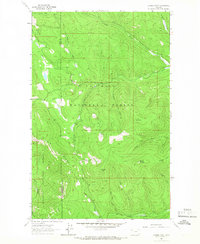
1963 Map of Dunsire Point
USGS Topo · Published 1966About this map
Kootenai National Forest and Flathead National Forest meet along the dramatic crest of the Elk Divide in this 1963 survey of the northern Montana backcountry. The landscape is defined by a dense network of drainages including Good Creek, Plume Creek, and Sheppard Creek that carve through high-elevation terrain. This specific map records the topographic details of Dunsire Point and Mount Swaney, capturing the region just as photogrammetric mapping began to provide a precise record of these once-remote peaks and ridgelines. The presence of a Gravel Pit near Good Creek and various Pack Trails suggests the early infrastructure of forest management and natural resource access. For researchers, the map clearly delineates the Lincoln Co Flathead Co boundary as it follows the topographical height of land, offering a clear picture of the county line's relationship to the physical geography.
Find a feature on this map
24 named features on this map. Tap any name to fly to it.
Don’t see what you’re looking for? This feature index may not catch every label — zoom into the map to look around manually.
Map Details
Editions of this 1963 Dunsire Point Map
2 editions found
Other maps of this area

1913 · Stryker
USGS Topo · 1:125,000

1916 · Stryker
USGS Topo · 1:125,000

1957 · Kalispell
USGS Topo · 1:250,000

1960 · Kalispell
USGS Topo · 1:250,000

1961 · Kalispell
USGS Topo · 1:250,000

1962 · Johnson Peak
USGS Topo · 1:24,000

1962 · Ashley Mountain
USGS Topo · 1:24,000

1963 · Sylvia Lake
USGS Topo · 1:24,000
1963 · Skillet Mountain
USGS Topo · 1:24,000

1963 · Sunday Mountain
USGS Topo · 1:24,000