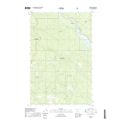
2020 Map of Radnor
USGS Topo · Published 2020About this map
Radnor sits along the Stillwater River at the eastern edge of the Whitefish Range, serving as a central point in this high-country landscape. The terrain is divided between the Kootenai National Forest and the Flathead National Forest, characterized by numerous glacial lakes including Upper Stillwater Lake, Lagoni Lake, and the remote Hole in the Wall Lake. Transportation and access across these heights are defined by a network of forest roads and the historic Old Fort Steele Trl, which skirts the river valley. The map provides clear detail for researchers following the drainage patterns of Le Beau Cr and Martin Cr, or those interested in the prominence of Ketowke Mtn and Adams Mtn as landmarks within the protected timberlands.
Find a feature on this map
43 named features on this map. Tap any name to fly to it.
Don’t see what you’re looking for? This feature index may not catch every label — zoom into the map to look around manually.
Map Details
Editions of this 2020 Radnor Map
This is the sole edition of this map. No revisions or reprints were ever made.
Other maps of this area

1913 · Stryker
USGS Topo · 1:125,000

1916 · Stryker
USGS Topo · 1:125,000

1957 · Kalispell
USGS Topo · 1:250,000

1960 · Kalispell
USGS Topo · 1:250,000

1961 · Kalispell
USGS Topo · 1:250,000

1962 · Johnson Peak
USGS Topo · 1:24,000
1962 · Tally Lake
USGS Topo · 1:24,000

1963 · Stryker
USGS Topo · 1:24,000

1963 · Sunday Mountain
USGS Topo · 1:24,000
1963 · Dunsire Point
USGS Topo · 1:24,000