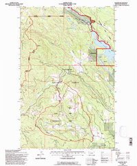
1994 Map of Radnor
USGS Topo · Published 1997About this map
The Stillwater River corridor dominates this northwestern Montana landscape, where industrial logging and conservation efforts converge within the Stillwater State Forest. The Burlington Northern railroad tracks parallel the river's path, tracing the valley floor beneath the high peaks of Ketowke Mountain and Grouse Mountain. This area serves as a managed timber environment, highlighted by the Miller Creek Demonstration Forest, which illustrates the intersection of forestry research and public land use in the late 20th century. High-elevation water bodies like Hole in the Wall Lake and the Martin Lakes are tucked into the drainages of the Flathead National Forest, while the presence of a Gravel Pit and a major powerline near Radnor indicates the essential infrastructure supporting these remote mountain reaches.
Find a feature on this map
30 named features on this map. Tap any name to fly to it.
Don’t see what you’re looking for? This feature index may not catch every label — zoom into the map to look around manually.
Map Details
Editions of this 1994 Radnor Map
This is the sole edition of this map. No revisions or reprints were ever made.
Other maps of this area

1913 · Stryker
USGS Topo · 1:125,000

1916 · Stryker
USGS Topo · 1:125,000

1957 · Kalispell
USGS Topo · 1:250,000

1960 · Kalispell
USGS Topo · 1:250,000

1961 · Kalispell
USGS Topo · 1:250,000

1962 · Johnson Peak
USGS Topo · 1:24,000
1962 · Tally Lake
USGS Topo · 1:24,000

1963 · Stryker
USGS Topo · 1:24,000

1963 · Sunday Mountain
USGS Topo · 1:24,000
1963 · Dunsire Point
USGS Topo · 1:24,000