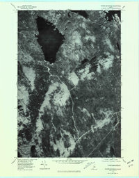
1978 Map of Ragged Mountain
USGS Topo · Published 1981About this map
Upper Jo-Mary Lake dominates the northwest corner of this 1978 orthophotoquad, its dark waters contrasted against the timbered terrain of Penobscot County. This aerial perspective, captured in late October, provides a clear view of the logging roads and clearings that mark the industrial forest landscape. Near the southeastern edge, the settlement of West Seboois sits along the rail line, representing a small hub of activity in an otherwise remote region. The topography is defined by Ragged Mountain, while the southern reaches are drained by the E Br Pleasant River. This survey captures the Maine woods just before the turn of the decade, showing the precise footprints of shorelines at South Twin Lake and the established network of resource extraction roads that weave through the backcountry.
Find a feature on this map
5 named features on this map. Tap any name to fly to it.
Don’t see what you’re looking for? This feature index may not catch every label — zoom into the map to look around manually.
Map Details
Editions of this 1978 Ragged Mountain Map
2 editions found
Other maps of this area

1940 · Sebec
USGS Topo · 1:48,000

1943 · Sebec
USGS Topo · 1:62,500

1947 · Schoodic
USGS Topo · 1:62,500

1949 · Schoodic
USGS Topo · 1:62,500

1951 · Norcross
USGS Topo · 1:62,500

1952 · Jo-Mary Mountain
USGS Topo · 1:62,500

1954 · Millinocket
USGS Topo · 1:250,000

1958 · Millinocket
USGS Topo · 1:250,000

1960 · Millinocket
USGS Topo · 1:250,000
1978 · Norcross
USGS Topo · 1:24,000