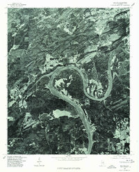
1975 Map of Ragland
USGS Topo · Published 1977About this map
Coosa River meanders sharply through the landscape of St. Clair County in this mid-1970s orthophotoquad, providing a literal aerial view of the terrain around Ragland. The image, derived from aerial photography taken in late 1975, reveals the specific contours of Logan Martin Lake and the surrounding woodlands and agricultural clearings. Unlike traditional line-drawn maps, this photo-based document shows the actual ground cover and the density of the forest as it existed just before the United States Bicentennial. The interplay between the industrial or residential structures in Ragland and the winding river channel highlights the region's reliance on the waterway for both geography and local industry.
Find a feature on this map
3 named features on this map. Tap any name to fly to it.
Don’t see what you’re looking for? This feature index may not catch every label — zoom into the map to look around manually.
Map Details
Editions of this 1975 Ragland Map
This is the sole edition of this map. No revisions or reprints were ever made.
Other maps of this area

1889 · Springville
USGS Topo · 1:125,000

1892 · Springville
USGS Topo · 1:125,000

1947 · Cox Gap
USGS Topo · 1:24,000

1947 · Eastaboga
USGS Topo · 1:24,000

1947 · Ragland
USGS Topo · 1:62,500

1947 · Ragland
USGS Topo · 1:24,000

1947 · Riverside
USGS Topo · 1:24,000

1947 · Francis Mill
USGS Topo · 1:24,000

1947 · Steele
USGS Topo · 1:62,500
1949 · Ohatchee
USGS Topo · 1:24,000