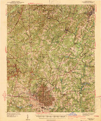
1954 Map of Raleigh
USGS Topo · Published 1954This historical map portrays the area of Raleigh in 1954, primarily covering Wake County as well as portions of Richmond County, Guilford County, Cumberland County, Durham, Scotland County, Johnston County, Alamance County, Orange County, Randolph County, Harnett County, Wayne County, Montgomery County, Moore County, Nash County, Anson County, Wilson County, Chatham County, Franklin County, Lee County, Sampson County, Hoke County, and Duplin County. Featuring a scale of 1:250000, this map provides a highly detailed snapshot of the terrain, roads, buildings, counties, and historical landmarks in the Raleigh region at the time. Published in 1954, it is the sole known edition of this map.
Find a feature on this map
199 named features on this map. Tap any name to fly to it.
Don’t see what you’re looking for? This feature index may not catch every label — zoom into the map to look around manually.
Map Details
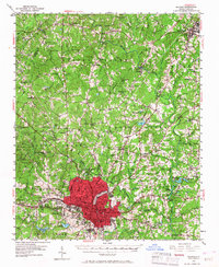
Editions of this 1954 Raleigh Map
This is the sole edition of this map. No revisions or reprints were ever made.
Historical Maps of Hope Valley West Through Time
6 maps found