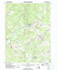
1993 Map of Ramey
USGS Topo · Published 1994About this map
Clearfield Creek carves a winding path through this corner of the Pennsylvania coalfields, where the early 1990s landscape is defined by extensive industrial activity and small valley settlements. The terrain is marked by numerous Strip Mine operations and a network of Old RR GR paths that speak to the region's heavy reliance on rail transport and resource extraction. Significant local infrastructure is concentrated near Madera and Ramey, including the Moshannon Valley Area Schs, while smaller hamlets like Belsena Mills and Hegarty Crossroads dot the tributary runs. For genealogists, the map is a dense resource of family history markers, noting locations such as Janesville (Smithville PO) and St Marys Cem. The presence of many Cem labels and dedicated landmarks like Mountz Mem Park highlights the established community roots that persisted even as mining shaped the physical geography of Beccaria and Bigler.
Find a feature on this map
65 named features on this map. Tap any name to fly to it.
Don’t see what you’re looking for? This feature index may not catch every label — zoom into the map to look around manually.
Map Details
Editions of this 1993 Ramey Map
This is the sole edition of this map. No revisions or reprints were ever made.
Other maps of this area

1902 · Patton
USGS Topo · 1:62,500

1903 · Curwensville
USGS Topo · 1:62,500

1903 · Houtzdale
USGS Topo · 1:62,500

1904 · Patton
USGS Topo · 1:62,500

1905 · Houtzdale
USGS Topo · 1:62,500

1920 · Altoona
USGS Topo · 1:62,500

1922 · Altoona
USGS Topo · 1:62,500

1939 · Curwensville
USGS Topo · 1:62,500

1942 · Curwensville
USGS Topo · 1:62,500

1943 · Punxsutawney
USGS Topo · 1:125,000