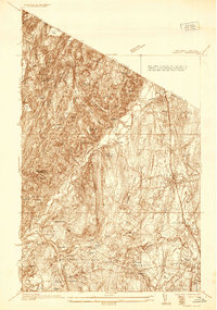
1936 Map of Ramsey
USGS Topo · Published 1936About this map
Ramapo River cuts a deep valley through this northern New Jersey landscape, separating the steep terrain of Hohokus Mountain from the growing residential corridors of the Erie RR. This 1935-1936 survey reveals a transition from the wilder, lake-dotted highlands of Skylands and Bear Swamp Lake to the established settlements of Ramsey, Mahwah, and Allendale. Large institutional properties and recreational camps dominate the wooded ridges, including the Immaculate Conception Seminary and the Don Bosco Institute. The abundance of private estates and water bodies like Havemeyer Reservoir and Macmillan Reservoir suggests a landscape being shaped for both water management and suburban retreat. To the south, the village centers of Wyckoff and Waldwick show a dense network of local roads and schools such as the Oakland House area, illustrating the early 20th-century expansion of Bergen County.
Find a feature on this map
68 named features on this map. Tap any name to fly to it.
Don’t see what you’re looking for? This feature index may not catch every label — zoom into the map to look around manually.
Map Details
Editions of this 1936 Ramsey Map
This is the sole edition of this map. No revisions or reprints were ever made.
Other maps of this area

1888 · Morristown
USGS Topo · 1:62,500

1888 · Paterson
USGS Topo · 1:62,500

1891 · Greenwood Lake
USGS Topo · 1:62,500

1891 · Ramapo
USGS Topo · 1:62,500

1892 · Paterson
USGS Topo · 1:62,500

1893 · Greenwood Lake
USGS Topo · 1:62,500

1893 · Ramapo
USGS Topo · 1:62,500

1894 · Morristown
USGS Topo · 1:62,500

1898 · Morristown
USGS Topo · 1:62,500

1898 · Paterson
USGS Topo · 1:62,500