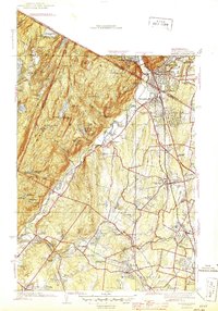
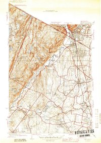
1945 Map of Ramsey
USGS Topo · Published 1945About this map
Ramapo Mountains and the Campgaw Mountain ridge dominate the western half of this mid-1940s landscape, creating a dramatic physical boundary between the wooded uplands and the burgeoning valley settlements. The Ramapo River cuts a path through this terrain, winding past the Immaculate Conception Seminary and the village of Darlington. To the east, the Erie railroad corridor serves as the primary spine for development, linking the established centers of Suffern, Mahwah, Ramsey, and Allendale.
Find a feature on this map
82 named features on this map. Tap any name to fly to it.
Don’t see what you’re looking for? This feature index may not catch every label — zoom into the map to look around manually.
Map Details
Editions of this 1945 Ramsey Map
2 editions found
Other maps of this area

1888 · Morristown
USGS Topo · 1:62,500

1888 · Paterson
USGS Topo · 1:62,500

1891 · Greenwood Lake
USGS Topo · 1:62,500

1891 · Ramapo
USGS Topo · 1:62,500

1892 · Paterson
USGS Topo · 1:62,500

1893 · Greenwood Lake
USGS Topo · 1:62,500

1893 · Ramapo
USGS Topo · 1:62,500

1894 · Morristown
USGS Topo · 1:62,500

1898 · Morristown
USGS Topo · 1:62,500

1898 · Paterson
USGS Topo · 1:62,500