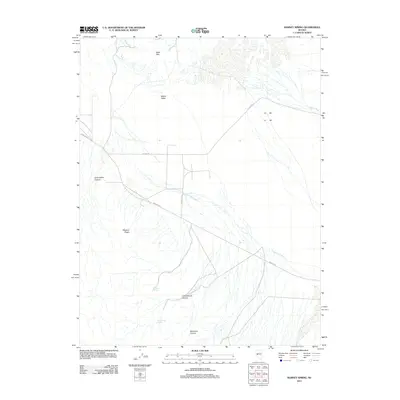
2011 Map of Ramsey Spring
USGS Topo · Published 2011About this map
Gabbs Valley and the dry alluvial expanses of Gabbs Wash dominate this desert landscape as it appeared in 2011. The map documents a rugged terrain defined by significant geographic markers like the Black Hills to the north and the prominent Mystery Ridge in the southwest. Arid drainage patterns are clearly delineated through the presence of Finger Rock Wash and several deep cuts into the mountain fronts, including Superstition Canyon and Boundary Canyon. Rare water sources in this environment, such as Ramsey Spring and Cottonwood Spring, are noted alongside the rudimentary road network of Rawhide Rd, Diamond A Rd, and H 2 Bar Rd. These features provide critical context for understanding 21st-century land use and navigation in this isolated section of Nye County.
Find a feature on this map
17 named features on this map. Tap any name to fly to it.
Don’t see what you’re looking for? This feature index may not catch every label — zoom into the map to look around manually.
Map Details
Editions of this 2011 Ramsey Spring Map
This is the sole edition of this map. No revisions or reprints were ever made.
Other maps of this area

1909 · Hawthorne
USGS Topo · 1:250,000

1911 · Hawthorne
USGS Topo · 1:250,000

1915 · Hawthorne
USGS Topo · 1:250,000

1948 · Walker Lake
USGS Topo · 1:250,000

1957 · Walker Lake
USGS Topo · 1:250,000

1962 · Walker Lake
USGS Topo · 1:250,000

1964 · Walker Lake
USGS Topo · 1:250,000
1979 · Ramsey Spring
USGS Topo · 1:24,000
1979 · Win Wan Flat
USGS Topo · 1:24,000
1979 · Mount Annie SE
USGS Topo · 1:24,000